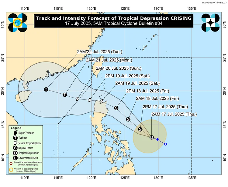
Tropical Cyclone Bulletin #4
Tropical Depression "Crising"
Tropical Depression "Crising"
Issued at 05:00 am, 17 July 2025
(Valid for broadcast until the next advisory to be issued at 11:00 AM today)
“CRISING” MAINTAINS ITS STRENGTH WHILE MOVING WEST NORTHWESTWARD OVER THE SEA EAST OF BICOL REGION.
HAZARDS AFFECTING LAND AREAS
Heavy Rainfall Outlook
Refer to Weather Advisory No. 7 issued at 5:00 AM today for the heavy rainfall outlook due to Tropical Cyclone CRISING and the Southwest Monsoon.
Severe Winds
The wind signals warn the public of the general wind threat over an area due to the tropical cyclone. Local winds may be slightly stronger/enhanced in coastal and upland/mountainous areas exposed to winds. Winds are less strong in areas sheltered from the prevailing wind direction.
Minimal to minor impacts from strong winds are possible within any of the areas under Wind Signal No. 1.
The highest Wind Signal which may be hoisted during the occurrence of CRISING is Wind Signal No. 3.
The Southwest Monsoon will bring strong to gale-force gusts over the following areas (especially in coastal and upland areas exposed to winds):
Today: Batangas, Quezon, Bicol Region, MIMAROPA, Visayas, Zamboanga del Norte, Camiguin, Surigao del Norte, Dinagat Islands, Davao Occidental, Davao Oriental, and Sarangani.
Tomorrow: Bataan, Metro Manila, CALABARZON, Bicol Region, MIMAROPA, Visayas, Zamboanga Peninsula, Basilan, Sulu, Tawi-Tawi, Misamis Occidental, Lanao del Norte, Camiguin, Surigao del Norte, Dinagat Islands, Davao Occidental, and Davao Oriental.
Saturday (19 July): Metro Manila, Central Luzon, CALABARZON, MIMAROPA, Bicol Region, Visayas, Zamboanga Peninsula, Misamis Occidental, Lanao Del Norte, Camiguin, Dinagat Islands, Davao Occidental, and Davao Oriental.
Coastal Inundation
There is a minimal to moderate risk of life-threatening storm surge with peak heights reaching 1.0 to 2.0 m in the next 48 hours over the low-lying or exposed coastal localities of Cagayan including Babuyan Islands and Isabela. Refer to Storm Surge Warning No. 1 issued at 2:00 AM today for the details.
HAZARDS AFFECTING COASTAL WATERS
24-Hour Sea Condition Outlook
Up to rough seas over the following coastal waters:
Up to 2.5 m: The western seaboard of Palawan; the northern and eastern seaboards of Catanduanes; the northern and western seaboards of Zamboanga del Norte and Camiguin; the southern seaboards of Negros Oriental, Siquijor, Bohol and Southern Leyte; the eastern seaboards of Davao Region; and the western seaboards of Surigao del Norte and Dinagat Islands.
Up to moderate seas over the following coastal waters:
Up to 2.0 m: The northwestern seaboard of Occidental Mindoro; the northwestern seaboard of Masbate; the southwestern seaboards of Antique and Negros Occidental; the eastern seaboards of Northern and Eastern Samar.
Mariners of motorbancas and similarly-sized vessels are advised to take precautionary measures while venturing out to sea and, if possible, avoid navigation under these conditions.
TRACK AND INTENSITY OUTLOOK
CRISING will move generally northwestward over the next 48 hours. A landfall scenario over mainland Cagayan tomorrow evening to Saturday (19 July) early morning is possible. Afterwards, it will move west northwestward traversing the northern portion of Northern Luzon, and may exit the Philippine Area of Responsibility by Saturday (19 July) evening or Sunday (20 July) morning.
CRISING is forecast to reach Tropical Storm category today. It is forecast to continue intensifying over the Philippine Sea and may reach Severe Tropical Storm category on Friday afternoon or evening before its approach to Northern Luzon.

Forecast Position
Jul 17, 2025 02:00 PM - 340 km East of Virac, Catanduanes
Jul 18, 2025 02:00 AM - 365 km East of Casiguran, Aurora
Jul 18, 2025 02:00 PM - 210 km East of Tuguegarao City, Cagayan
Jul 19, 2025 02:00 AM - In the vicinity of Ballesteros, Cagayan
Jul 19, 2025 02:00 PM - 100 km West Northwest of Laoag City, Ilocos Norte
Jul 20, 2025 02:00 AM - 285 km West Northwest of Laoag City, Ilocos Norte (OUTSIDE PAR)
Jul 21, 2025 02:00 AM - 495 km West of Calayan, Cagayan (OUTSIDE PAR)
Jul 22, 2025 02:00 AM - 915 km West of Extreme Northern Luzon (OUTSIDE PAR)
Wind Signal (Areas with TCWS)
Tropical Cyclone Wind Signal no.1
Affected Areas
Luzon
Cagayan including Babuyan Islands, Isabela, the northeastern portion of Aurora (Dilasag, Casiguran, Dinalungan, Dipaculao), Quirino, Kalinga, the eastern portion of Mountain Province (Sadanga, Barlig, Paracelis, Natonin), the eastern portion of Ifugao (Alfonso Lista, Aguinaldo, Mayoyao, Banaue, Hingyon, Lagawe, Lamut), the northeastern portion of Nueva Vizcaya (Kasibu, Quezon, Bagabag, Diadi) and Apayao
Visayas
-
Mindanao
-
Meteorological Condition
A tropical cyclone will affect the locality.
Winds of 39-61 km/h may be expected in at least 36 hours or intermittent rains may be expected within 36 hours. (When the tropical cyclone develops very close to the locality a shorter lead time of the occurrence of the winds will be specified in the warning bulletin.)
Impact of the Wind
Very light or no damage to low risk structures.
Light damage to medium to high risk structures.
Slight damage to some houses of very light materials or makeshift structures in exposed communities. Some banana plants are tilted, a few downed and leaves are generally damaged.
Twigs of small trees may be broken.
Rice crops, however, may suffer significant damage when it is in its flowering stage.
Precautionary Measures
When the tropical cyclone is strong or is intensifying and is moving closer, this signal may be upgraded to the next higher level.
The waves on coastal waters may gradually develop and become bigger and higher.
The people are advised to listen to the latest severe weather bulletin issued by PAGASA every six hours. In the meantime, business may be carried out as usual except when flood occur.
Disaster preparedness is activated to alert status.
What To Do
Inspect your house if necessary repair/fixing is needed.
Clean up drainage system.
Harvest crops tha can be yielded.
Monitor the latest Severe Weather Bulletin issued By PAGASA every six hours and hourly updates.
My Mentions


2 comments