


Supporters


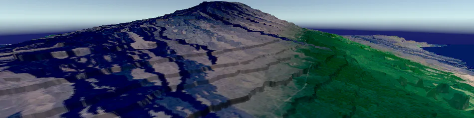
Big Island of Hawai'i, is a geovisualization for use in conjunction with a college level laboratory science course. This geovisualization is derived from the Big Island of Hawai‘i Landsat Mosaic and meteorological data (available from NOAA).
Supporting materials related to those courses should be obtained from the course instructor.
Minimum Requirements:
OS: Windows 8, macOS El Capitan
System type: 64-bit operating system (x86-64) (32-bit OSs are not supported)
Processor: Intel Core i3-6100u, or equivalent x86-64 (ARM not supported)
Graphics: HD Graphics 520, or equivalent
System Memory: 4 GB RAM
Storage: 500 MB Hard drive space
Recommended:
OS: Windows 10, macOS Catalina
System type: 64-bit operating system (x86-64)
Processor: Intel Core i5-7400, or equivalent x86-64 (ARM not supported)
Graphics: Radeon Pro 555, Nvidia GeForce GTX 1050, or equivalent
System Memory: 8 GB RAM
Storage: 500 MB Hard drive space
Current Release
1.1.0 Release supports both Windows and macOS. With the following features:
Point & Click Fast Travel system to real world coordinates.
Manual Latitude and Longitude coordinate entry.
Air Lift slow travel alternative.
Import of KML point features for Preset Fast Travel points.
Dew Point and Rainfall numeric data.
Adjustable terrain overlays: LandSat, Dew Point, and Rainfall.
Selectable color ramps for terrain overlays & inset maps.
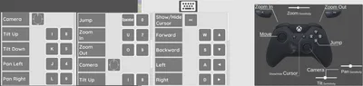
Limited controller support on Windows & macOS.
Faster Terrain Loading.
Non-course uses
This geovisualization can be used as a stand-alone exploration of the Big Island of Hawai'i. Two Bent Coppers follows three layer design approach: Core, Guided, Explore.
Core is the minimum feature set required to conduct lab course exercises.
Guided is internal direction and assistance navigating course exercises.
Explore is the free examination of the full extent, and visualized data. Using tools available for the course exercises.
As of 1.0.0 there is no internal Guided aspect to this geovisualization. It was not included by request of various course instructors. This is currently being handled externally. For example (provided with permission): http://www.public.asu.edu/~atrid/HawaiiGame112_PhysicalGeographyFeb10.pdf
Is this a game?
By strict definition, no. It is a geovisualization for exploring a select data set. We hope to include "entertaining" tools for exploring that data, but our primary focus is on supporting scientifically valid material. The "gamification" comes second.
Patch Notes
See first message below description.
Known issues in 1.1.0
Avatar selection not saving.
Field of View not updating.

Mild Cartoon Violence
Comical Shenanigans